Road Trip Day 8
2006 Road Trip Vacation – Saturday 2006-09-30
- Checked out of the Russellville Inn, $59 per night – very nice clean room, internet access, very nice place – I would say it’s the best value of any place I’ve stayed so far
- I’m listening to this CD Dark Star Safari by Paul Thoreaux, and he’s talking about how the regions of Africa during certain government regimes in different countries would promote displacement of white land owners and he labels it as state sponsored terrorism… and what it has me wondering about is the early American displacement of Native Americans and Mexicans as the United States was expanding in the 1800’s… I suppose the parallel would be more accurate if the Mexicans and Native Americans were to now displace us and take back the lands…. Do we or could we have called our expansion in the 1800’s state sponsored terrorism? What if we were to find ourselves a minority to Mexican born American citizens and/or residents? If they were to begin taking back original Mexican territory and claiming it as Mexican how would we view that? It strikes me as not totally out of the realm of possibility given where some places in the southwest have gone recently in terms of dual languages among other things… hmmm… much to ponder…
- I got off of 17 North onto this road that says TVA Muscle Shoals and some Dam so I’m gonna check it out…
- Wilson Dam and Visitors center is where I’m headed…
- I keep seeing signs that say that this is a
- I just drove across Wilson dam which is really cool and I was able to get a couple of shots as I drove across but unfortunately all of the visitor centers and parks to get a good view are closed for some reason… bummer…

- Wilson Dam is on the Tennessee river – I’m crossing it now on 13/17 north going into
- The way the signage works around here is a bit of a pain in the ass so it’s anyone’s guess as to which road I’m going to come out of Florence on…
- I’m on 17 north/157 north…
- I’m a little bummed out – I was just heading north out of … uh… I don’t even know what this place is… and I said to myself I’ll get something to eat and then I’ll see if I can clean a spot off of my lens or mirror – so it appears that it’s dust on the sensor so even with the xti sensor cleaning system it looks like I’m dealing with dust on my sensor – gah!
- I’m in
- This part of
- I might also make the suggestion for people not to drive the stretch north of Waynesboro in the dark – there are several 20 MPH turns and the drop offs are pretty precipitous – it would pretty much ruin your night…
- This area of Tennessee I think, Perry county is one of the more interesting ones with striated rock cliffs and twisty – amazing hills – I like it a lot here…

- So I’m at the junction of 17 and I-40 is a lot of
- I’m in Erin, TN and I stopped and got some pizza, gas, cash – of course there was another stray dog – a friendly yellow lab – I think a tourist flagged down a cop while I was in the shop to try to do something because they were out there when I came out and I didn’t see the dog – damn friendly dog though – extremely thin…

- So now that I’m kinda set for a little while I’m going to head out on 49 west which I’m going to take… actually… hold on…
- Yeah – 49 west to 79 which I should be able to take west again then take the “trace” up through the “land between the lakes”
- Ya know you think of everything around here being really old, but
- Well I gave some money to a local fire department standing at the intersection with their buckets and in the process I think I missed my turn – so I’m turning around to get back on track…
- I don’t know what body of water this is on 49 8miles south of Dover – large body of water – kinda boggy with large hills and trees and what not – very scenic

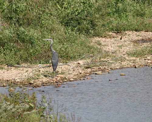
- I stopped in this wildlife reserve… uh….
- So what I was saying is that I stopped in this wildlife preserve because my overactive bladder is getting the best of me today – must be all the water I’m drinking … but, stopped and got some pix of hawks and just now I saw about 20 turkey vultures circling in the sky


- This is cross creeks national wildlife refuge, south cross creek reservoir – so finally my camera batteries go dead for the first time this week, so I’m glad I bought 2 additional nicad batteries and the battery pack handle grip J
- The repair shop is just south of

- The location of
- And I’m heading toward the turn that says Land between the lakes National Recreation area…


- I’m in
- Rock on… getting into an Elk and Bison Prairie that’s normally a fee entry but today is evidently national public lands day, so it’s free of charge!
- I hear-um, but no-see-um
- So I saw them – absolutely heard them before I saw them… it’s interesting to watch the bull elk with their herds… they round up their herd and scream out in what sounds like a “dinosaur” bellow to drive them away from the crowd – I had to chuckle at this little male elk doing his impression of a big male elk – sounded more like squeaks!


- That was a pretty park – you could easily spend a lot of time there… I can see bring the boat down for boating fishing camping and… ouch…. My foot is killing me….
- This little town (grand rivers) is packed although I can’t exactly tell you why, it’s simply packed with cars and people…
- I got off of the highway that was the trace and came through grand rivers in hopes that I could hook up with 641 so I’m hoping that still remains the case…
- Alright so I’m at the intersection of this thing… so I’m taking 641 east…
- Just went over the
- OK – I’m getting off of 60 east and onto 91 north – the map shows a ferry crossing which is not really what I wanted, but it’s a bit of a drive to the free bridge…
- That was unexpected – I just drove by an Amish horse drawn buggy…
- It’s 5:13 and I’m sitting at the ferry that will take me from

- Back in
- I was thinking I was going to drive all the way home and now I’m having second thoughts – I came into Cave in Rock Illinois and I see that I’ve entered hardin county and this is an area that’s prominent in my genealogy – so I’m seriously considering staying over and hitting a couple of cemeteries in the morning – depends on if I can find a decent place to stay – not really willing to deal with another bug infested hotel so we’ll see…

- I’ve gotten onto 13 east to go to Shawneetown – one of the towns in my genealogy that I’ve always wondered about –
- Old Shawneetown is the oldest town in Illinois… and it’s pretty beaten up now… it’s only 400 people and the nicest places in here are trashed up mobile homes … well there is one nice brick house, but generally it’s a wreck… which is sad… it proves out one reason why people moved out as apparently they moved the town a number of times because of the flooding ohio river.. the new shawneetown is 3 miles to the west of this…

- I didn’t see any cemeteries as I came through so … hard to tell… uh…
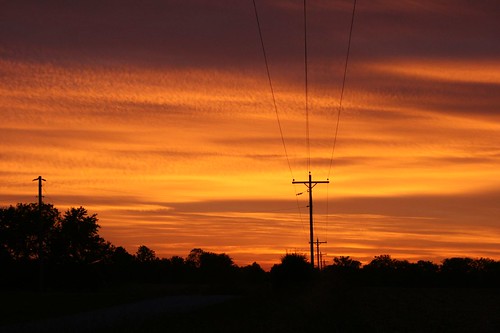
- The most spectacular sunset – fiery red clouds - just gorgeous – 1 North turned into 45 north J


- I finished Dark Star Safari – next Harlan Corbin’s The Innocent
- Staying Matoon tonight - gonna do some local snooping in the morning
No comments:
Post a Comment